BANGKOK (AP) — Flooding triggered by heavy monsoon rains in Myanmar’s southern areas has displaced more than 14,000 people and disrupted traffic on the rail lines that connect the country’s biggest cities, officials and state-run media said Monday.
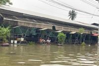
State television MRTV reported Monday evening that the number of displaced people in Bago township, about 68 kilometers (42 miles) northeast of Yangon, the country's biggest city, had climbed to that figure, and they were taking shelter in 36 relief camps. It said almost 1,000 more people in Mon state's township, just east of Bago, were sheltering in three relief camps, and there some evacuations in a northern part of Yangon.
A senior official at the Ministry of Social Welfare, Relief and Resettlement, Lay Shwe Zin Oo, said that constant rainfall in the Bago region that began last week caused the flooding in the low-lying areas of its capital, Bago township. She said there were no casualties reported so far.
Bago township recorded 7.87 inches (200 millimeters) of rainfall, its highest level in 59 years, Myanmar’s Meteorological Department said Sunday. Rain or thundershowers was forecast for across the country until noon on Tuesday.
One of the leaders of an emergency rescue team in Bago told The Associated Press that the flooding was up to about eight feet (2.3 meters) deep in low-lying areas and four feet (1.2 meters) downtown.
“Almost the whole area of the town was flooded,” Thant Zin Maung, chairman of the Mizzima Thukha Charity Foundation said by phone on Monday. “It is the third flood in the town this year and the worst in many years. All the monasteries in the town have opened relief camps. Charity organizations are evacuating people from low-lying areas as much as they can.”
A 55-year-old resident of Bago’s Pan Hlaing ward interviewed by phone said the floodwaters were as much as six feet (1.8 meters) deep in her neighborhood, and her family members were living on the second and third floors of their house.
The woman, who spoke on condition of anonymity because Myanmar's military government prefers to tightly control the release of information, said the water was still rising steadily in her neighborhood, which had never flooded badly before.
Social Welfare Ministry official Lay Shwe Zin Oo said Bago evacuees were sheltering in relief camps, schools and Buddhist monasteries, while the authorities were providing food, drinking water and other essential assistance.
Reports in the state-run Myanmar Alinn newspaper on Monday said that trains that departed from Mandalay, the country’s second-largest city in central Myanmar, and from southern Mawlamyine township were halted en route. Scheduled departures from Yangon, the biggest city in the country, were canceled after rail lines were flooded by the rapid flow of water from mountain torrents and the spillage from dams in the Bago region.
MRTV said almost 1,000 people in Mon state’s Kyaikto township, just east of Bago, were sheltering in three relief camps, and there some evacuations as well in a northern part of Yangon.
Myanmar experiences extreme weather virtually every year during the monsoon season. In 2008, Cyclone Nargis killed more than 138,000 people. In July and August this year, floods in Mon, Kayin and Rakhine states and the regions of Bago and Magway killed five people and displaced about 60,000.


